
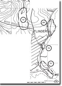
72. Flinders - Dodds Creek Capture
|
This information has been developed from one or more of these publications:
|
| Location: | Flinders – 3266413 to 267425. Two kilometres to three kilometres north-east of Flinders. | |
| Access: | Boyds Road. | |
| Ownership: | Private land. | |
| Geomorphology: | The site encloses an area of river capture and drainage reversal involving Dodds Creek and Musk Creek. The upper reach of Dodds Creek is now a dry valley, with a wind gap north of Boyds Road dividing the southward draining valley from that draining north into Musk Creek. The captured segment of Dodds Creek joins Musk Creek at right angles forming distinctive ‘elbow of capture’. | |
| Significance: | Regional. This small stream system is a very clear illustration of one process of stream capture. | |
| Management: | Class 2. Close subdivision of any area enclosed in the site should not be permitted. This is particularly the case for the area marked ‘ wind gap’ . | |

© State of Victoria (Agriculture Victoria) 1996 - .

This work, Victorian Resources Online, is licensed under a Creative Commons Attribution 4.0 licence. You are free to re-use the work under that licence, on the condition that you credit the State of Victoria (Agriculture Victoria) as author, indicate if changes were made and comply with the other licence terms.
The licence does not apply to ‘branding’ or some ‘images or photographs’ that may be owned by third parties. We ask you to seek prior approval to use images using the VRO feedback form. Access to higher quality images can also be provided on request.
This page was last updated on .