
82. Chinaman Island to Blind Bight
|
This information has been developed from one or more of these publications:
|
| Location: | Devon Meadows – 520670 to 547683. All of Chinaman Island and intertidal areas adjacent to the island, and the coastline extending inland for approximately 100 metres along shoreline north-east of Chinaman Island. | 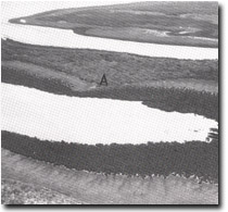 Relict spit (A) on Chinaman Island. Rutherford Inlet and Quail Island in background, Sites 80, 82. |
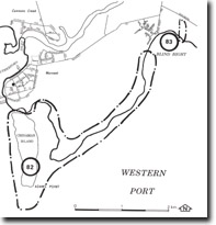
| Access: | Rutherford Parade (Warneet) and Blind Bight Road. Chinaman Island is accessible at low tide by fording a small tidal creek in the north and landing may be made by boat on the western shore from Rutherford Inlet. | |
| Ownership: | Crown Land and some private land. | |
| Geomorphology: | Chinaman Island preserves a Cranbourne Sand topography similar to that on Quail Island. There are also abandoned beaches and spits, and on the western shore on Rutherford Inlet there are major outcrops of a highly ferruginous sandstone which forms low cliff, shore platforms and cobble beaches. On the mainland coast north-east from Adams Point to Blind Bight there are low parallel sand ridges that lie inland of the salt marsh zone and follow the trend to the present shoreline. | |
| Significance: | Regional. The stratigraphic position of the ferruginous sandstones is not understood. It is not clear if they have been derived from the Baxter Sandstone or the Warneet Beds, or are indurated layers of the Cranbourne Sands. The parallel sand ridges are evidence of higher sea level and/or stronger wave action in the northern part of Westernport Bay. | |
| Management: | Class 2. No coastal engineering works should be undertaken that would obscure the sandstone outcrops or the relict spits on the shores of Chinaman Island. No dumping of dredged material in the mangrove zone should be permitted as this causes rapid mortality or mangroves as evidenced by the destruction of the stand immediately south of Blind Bight. The parallel sand ridges that extend south from Blind Bight should be left undisturbed. | |
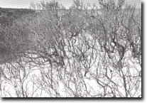 Mangroves killed by sand smothering following dredging of Blind Bight, Site 82. |

© State of Victoria (Agriculture Victoria) 1996 - .

This work, Victorian Resources Online, is licensed under a Creative Commons Attribution 4.0 licence. You are free to re-use the work under that licence, on the condition that you credit the State of Victoria (Agriculture Victoria) as author, indicate if changes were made and comply with the other licence terms.
The licence does not apply to ‘branding’ or some ‘images or photographs’ that may be owned by third parties. We ask you to seek prior approval to use images using the VRO feedback form. Access to higher quality images can also be provided on request.
This page was last updated on .