
221. Barrallier Island
|
This information has been developed from one or more of these publications:
|
| Location: | Barrallier - 524620. 1 km north of French Island. | 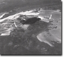 Long gravel pits (arrowed) on Barrallier Island. Mangroves on sheltered coast (A), Site 221. |
Access: | The island is accessible by boat at high tides. | |
Ownership: | Crown land. | |
Geology/Geomorphology: | This is a small depositional island built of gravels derived from ferruginous sandstone. The sands and gravels of the island have built up on the tidal flats and may have a basement of Baxter Formation sediments as there are outcrops of this material nearby at Scrub Point on French Island and Crawfish Rock. The higher parts of the island are above high tide level and carry a sparse scrub and grass vegetation and there are mangroves on the sheltered southern shore. Two long gravel spits extend from the island. | |
Significance: | Regional. Barrallier is one of several small gravelly islands in Westernport whose configuration changes rapidly in response to storms. Longer-term changes have been noted from study of aerial photographs. The island probably represents a higher area in the pre-Holocene terrain now submerged by the waters of Westernport and rests as a basement of ferruginous sandstone similar to that a Crawfish Rock. | |
Management: | Class 1. Removal of gravels or building of any structure on the island should be prohibited. | |
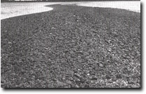 Gravel spit, Barrallier Island, Site 221 | 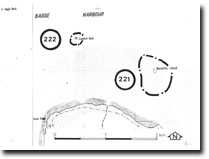 Site 221, Barrallier Island and Site 222, Crawfish Rock |

© State of Victoria (Agriculture Victoria) 1996 - .

This work, Victorian Resources Online, is licensed under a Creative Commons Attribution 4.0 licence. You are free to re-use the work under that licence, on the condition that you credit the State of Victoria (Agriculture Victoria) as author, indicate if changes were made and comply with the other licence terms.
The licence does not apply to ‘branding’ or some ‘images or photographs’ that may be owned by third parties. We ask you to seek prior approval to use images using the VRO feedback form. Access to higher quality images can also be provided on request.
This page was last updated on .