
39. Langwarrin - Silurian Outcrop
|
This information has been developed from one or more of these publications:
|
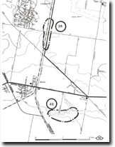
| Location: | Baxter – 390725. Railway cutting 500 metres south of Langwarrin railway station and road cutting on McLelland Drive (also known as Boundary Road) south of Robinsons Road. | 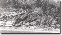 Folded and faulted Silurian sediments along McLelland Drive (Boundary Road), Langwarrin, Site 39. |
| Access: | McLelland Drive. | |
| Ownership: | Crown Land. | |
| Geology/Geomorphology: | Shales, mudstones, and thin sandstone beds are exposed in the cuttings. The beds in the railway cutting strike north-north-west and dip eastwards at 45°. Keble (1950) reported fossils including graptolites which indicated a lower Silurian age. The beds in the road cutting are gently folded and are faulted in the northern section of the exposure. | |
| Significance: | Regional. The outcrop lies close to the top structural axis of the Mornington Peninsula and is of interest to demonstrate the position of the Silurian strata in relation to that axis. | |
| Management: | Class 2. Activities that caused the outcrop to be obscured should not be permitted. | |

© State of Victoria (Agriculture Victoria) 1996 - .

This work, Victorian Resources Online, is licensed under a Creative Commons Attribution 4.0 licence. You are free to re-use the work under that licence, on the condition that you credit the State of Victoria (Agriculture Victoria) as author, indicate if changes were made and comply with the other licence terms.
The licence does not apply to ‘branding’ or some ‘images or photographs’ that may be owned by third parties. We ask you to seek prior approval to use images using the VRO feedback form. Access to higher quality images can also be provided on request.
This page was last updated on .