
46. Bittern West - Ordovician Sediments
|
This information has been developed from one or more of these publications:
|
| Location: | Balcombe – 350565. Five kilometres west of Bittern. | 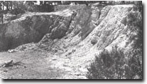 Folded Ordovician sediments at Hunts Road Quarry, Site 46. |
| Access: | Hunts Road. | |
| Ownership: | Private land. | |
| Geology: | An abandoned quarry exposes a highly silicified slate interbedded with quartzite. The beds are folded into a northerly plunging anticline. | |
| Significance: | Regional. This is one of the best exposures of folded structures in Ordovician strata in the Westernport Bay catchment. | |
| Management: | Class 2. Filling or reclamation of the quarry should not be permitted as this would obscure the significant outcrops. | |

© State of Victoria (Agriculture Victoria) 1996 - .

This work, Victorian Resources Online, is licensed under a Creative Commons Attribution 4.0 licence. You are free to re-use the work under that licence, on the condition that you credit the State of Victoria (Agriculture Victoria) as author, indicate if changes were made and comply with the other licence terms.
The licence does not apply to ‘branding’ or some ‘images or photographs’ that may be owned by third parties. We ask you to seek prior approval to use images using the VRO feedback form. Access to higher quality images can also be provided on request.
This page was last updated on .