
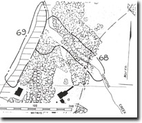
PP68. Gunyong (Grices) Creek - Manyung Fault
|
This information has been developed from one or more of these publications:
|
| Location: | 309712. Approximately lower 100 m sector of the Gunyong Creek valley. | 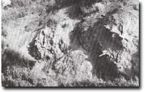 Site 68. Dipping Balcombe Clay beds in Gunyong Creek. (Concretions are arrowed). |
Access: | From Moondah Beach via Sturio Pde, Mt Eliza. | |
| Ownership/Managing Authority: | Private land. | |
Site Description: | The floor and valley sides of Gunyong Creek have significant exposures of Balcombe Clay. These are best seen on the southern side of the valley immediately upstream from the beach where they dip north at 35o. The beds contain abundant fossils and have numerous concretions. About 120 m upstream, the outcrop is more restricted but dips at 60o due to drag on the Manyung Fault. The fault crosses the creek about 30 m north of this steep dipping sector and faults Older Basalt against the Balcombe Clay. The variable dip of the Balcombe Clay beds is a clear expression of the drag produced by the Manyung Fault. | |
Significance: | Regional. The site is a significant exposure of the Balcombe Clay, is a major fossil site in this material and includes abundant calcareous nodules. It is an important site to demonstrate the occurrence and alignment of the Manyung Fault. | |
Management Considerations: | Class 2. The site is heavily overgrown and access to the upper creek exposures is difficult. Arrangement is required with the landowner to allow a cut track to be maintained to the site to allow access for genuine users. It is preferred that the valley sides where the formation outcrops be left as active landslip areas to allow the exposure to be maintained. Diversion of the creek or artificial stabilization of the valley sides should be discouraged as should land use that would require the slopes to be stabilized. In the long term, the acquisition of the lower 150 m of the valley into public ownership would be preferred. | |
References: | Keble, R.A. (1950). The Mornington Peninsula. Mem. Geol. Surv. Vict. 17. Gostin, V.A. (1966). Tertiary stratigraphy of the Mornington district, Victoria. Proc. R. Soc. Vict., 79, 459-512. | |

© State of Victoria (Agriculture Victoria) 1996 - .

This work, Victorian Resources Online, is licensed under a Creative Commons Attribution 4.0 licence. You are free to re-use the work under that licence, on the condition that you credit the State of Victoria (Agriculture Victoria) as author, indicate if changes were made and comply with the other licence terms.
The licence does not apply to ‘branding’ or some ‘images or photographs’ that may be owned by third parties. We ask you to seek prior approval to use images using the VRO feedback form. Access to higher quality images can also be provided on request.
This page was last updated on .