
20. St Germain - Former Stream Courses
|
This information has been developed from one or more of these publications:
|
Location: | Pakenham – 582803. Eight kilometres east of Cranbourne. | |
| Access: | Pound Road and Chasemore Road. | |
| Ownership: | Private land. | |
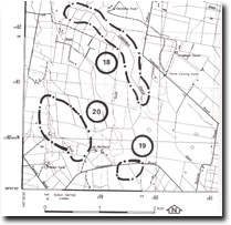
| Geomorphology: | Trending parallel to the present channel of the Cardinia Creek are traces of former stream courses. They are difficult to perceive on the ground but may be detected on aerial photographs. Hills (1942), suggested that on the basis of meander amplitude, these were independent of Cardinia Creek, and were traces of a larger stream with a drainage source some distance to the north-west. | |
| Significance: | Regional. The stream traces may be used to assist in the interpretation of the drainage patterns that contributed to the formation of the extensive (now drained) wetlands to the north of Westernport Bay. | |
| Management: | Class 3. Intensive subdivision or large scale excavation or building works that would obscure the stream should be prohibited. | |
References: | Hills, E.S. (1942). The physiography of the Koo-Wee-Rup Swamp. Proc. Roy. Soc. Vict. 54 (1) 79-92. | |

© State of Victoria (Agriculture Victoria) 1996 - .

This work, Victorian Resources Online, is licensed under a Creative Commons Attribution 4.0 licence. You are free to re-use the work under that licence, on the condition that you credit the State of Victoria (Agriculture Victoria) as author, indicate if changes were made and comply with the other licence terms.
The licence does not apply to ‘branding’ or some ‘images or photographs’ that may be owned by third parties. We ask you to seek prior approval to use images using the VRO feedback form. Access to higher quality images can also be provided on request.
This page was last updated on .