
75. Shoreham - Silurian Inlier
|
This information has been developed from one or more of these publications:
|
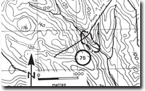
| Location: | Flinders – 263449. Four kilometres west of Shoreham. | |
| Access: | Punty Land. | |
| Ownership: | Private land. | |
| Geology: | A poorly exposed outcrop of mudstones on a tributary of Mantons Creek was described by Keble (1950) as Silurian. The creek bank and the old road cutting which served as the reference site for Keble are now overgrown and the outcrops are obscured. | |
| Significance: | Regional. The inlier represents a structural or relief high of the Palaeozoic basement rocks. It therefore reduces or limits the thickness of the Older Volcanics here to one hundred metres or less, compared with a thickness of several hundred metres near Flinders. | |
| Management: | Class 3. Quarrying or excavation at the site would expose more of the basement rock and could be permitted. As the outcrop is limited in extent, construction activities that would cover most of the outcrop should not be permitted. | |
References: | Keble, R.A. (1950). The Mornington Peninsula. Geol. Surv. Vict. Memoir 17. | |

© State of Victoria (Agriculture Victoria) 1996 - .

This work, Victorian Resources Online, is licensed under a Creative Commons Attribution 4.0 licence. You are free to re-use the work under that licence, on the condition that you credit the State of Victoria (Agriculture Victoria) as author, indicate if changes were made and comply with the other licence terms.
The licence does not apply to ‘branding’ or some ‘images or photographs’ that may be owned by third parties. We ask you to seek prior approval to use images using the VRO feedback form. Access to higher quality images can also be provided on request.
This page was last updated on .