
19. St Germain - Cardinia Sand
|
This information has been developed from one or more of these publications:
|
Location: | Pakenham – 595795. Four kilometres north-west of Cardinia. | 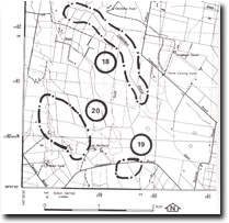 Site 19 |
| Access: | Chasemore Road. | |
| Ownership: | Private land. | |
| Geomorphology: | A broad low ridge crossed by Chasemore Road consists of unsorted sands and clayey sands. A small borrow pit in a field on the south side of the road shows a section in this material. Jenkin (1962) stated the sands are of fluvial origin, and later suggested they are probably levee banks that belong to a phase of higher velocity river discharge prior to the development of the swamplands but after the deposition of the aeolian Cranbourne Sands. The sands were referred to by Jenkin (1962) as the Cardinia Sands. Thompson (1974) implies that the sands are of aeolian rather than fluvial origin, by describing them as remnants of the Cranbourne Sands. | |
| Significance: | Regional. The sands indicate an earlier Pleistocene climatic and fluvial environment different from the present. This resulted in depositional landforms that are no longer being formed in the area. | |
| Management: | Class 2. Complete removal of all the sand deposits should be permitted. Small scale barrow pits are of interest however, as they provide a cross section into the deposit. | |
References: | Hills, E.S. (1942). The physiography of the Koo-Wee-Rup Swamp. Proc. Roy. Soc. Vict. 54 (1) 79-92. Jenkin, J.J. (1962). The geology and hdydrogeology of the Westernport area. Dept. of Mines, Vict. Underground Water Investigation Rept. No. 4 Jenkin, J.J. (1974). The geology of the Mornington Peninsula and Westernport. Geol. Surv. Rept. No. 1974/3. Thompson, B.R. (1974). The geology and hydrogeology of the Westernport sunklands. Geol. Surv. Rept. 1974/1. | |

© State of Victoria (Agriculture Victoria) 1996 - .

This work, Victorian Resources Online, is licensed under a Creative Commons Attribution 4.0 licence. You are free to re-use the work under that licence, on the condition that you credit the State of Victoria (Agriculture Victoria) as author, indicate if changes were made and comply with the other licence terms.
The licence does not apply to ‘branding’ or some ‘images or photographs’ that may be owned by third parties. We ask you to seek prior approval to use images using the VRO feedback form. Access to higher quality images can also be provided on request.
This page was last updated on .