
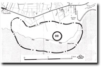
88. Pelican Point - Coastal Deposits
|
This information has been developed from one or more of these publications:
|
| Location: | Tooradin – 590680 to 615680. Coastal area extending from 1 km south-east of Tooradin to Pelican Point. | 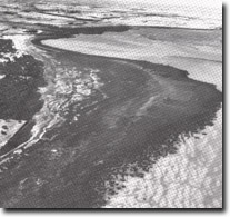 Mangrove and salt marsh zones at Pelican Point, Site 88 |
| Access: | No public road access is possible. The nearest public road is the South Gippsland Highway. | |
| Ownership: | Crown land and private land. | |
| Geomorphology: | The site contains sandy intertidal flats, chenier ridges, mangrove and salt marsh zones, backed by Holocene and Pleistocene sand ridges. The Holocene dunes are parallel and follow that trend of the coastline but the Pleistocene ridges are irregular. Between the dune ridges are swampy depressions. The intertidal zone has a sandy substrate and this accounts for the relatively narrow mangrove fringe compared with the wide saltmarsh zone, the reticulate pattern of tidal creeks, and the poor development of tidal creeks across the salt marsh. At the base of several of the tidal channels are outcrops of freshwater peat which are part of the swamp deposits underlying the Koo-Wee-Rup plain. | |
| Significance: | Regional. The area includes a tidal drainage pattern not widely represented in Westernport Bay. It also includes a vegetation sequence related to geomorphology, with Eucalyptus woodland and Melaleuca swamp on the sand ridges behind the salt marsh zone. The age of the various sand ridges needs more detailed study. This is one of the few coastal exposures of the freshwater peats. | |
| Management: | Class 1. Further drainage and clearing of any area in the site should be prohibited. Land reclamation projects, development of boat launching or other marine facilities should be prohibited. | |
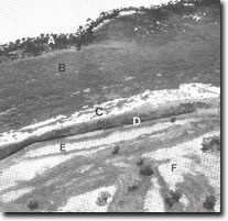 Mangrove (A), salt marsh (B), cheniers (arrows), brackish pools (C), Melaleuca swamp (D), Holocene sand ridge (E), Cranbourne Sand ridge (F). Pelican Point, Site 88 | 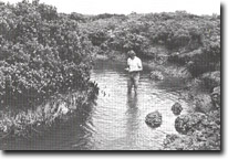 Tidal channel exposing freshwater peat of the Koo-Wee-Rup Swamp, Site 88 |

© State of Victoria (Agriculture Victoria) 1996 - .

This work, Victorian Resources Online, is licensed under a Creative Commons Attribution 4.0 licence. You are free to re-use the work under that licence, on the condition that you credit the State of Victoria (Agriculture Victoria) as author, indicate if changes were made and comply with the other licence terms.
The licence does not apply to ‘branding’ or some ‘images or photographs’ that may be owned by third parties. We ask you to seek prior approval to use images using the VRO feedback form. Access to higher quality images can also be provided on request.
This page was last updated on .