
77. Clyde - Baxter Formation
|
This information has been developed from one or more of these publications:
|
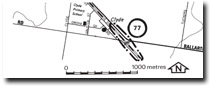
| Location: | Devon Meadows – 538780. The cutting for the railway south-east of Clyde railway station. | |
| Access: | Ballarto Toad. | |
| Ownership: | Crown Land. | |
| Geology: | The railway cutting provides a geological section into the Baxter Sandstone, a series of fine grained clayey sands and sandy clays with occasional lenses of coarser sand and fine gravels. The beds belong to the Baxter Sandstone (Jenkin, 1962), later described as the Baxter Formation by Thompson (1974). To the south the beds overlie weathered Older Volcanics. | |
| Significance: | Regional. The cutting provides one of the few sections in the Baxter Formation, one of the main Tertiary rock formations of the Westernport Bay catchment. | |
| Management: | Class 2. Construction work that would obscure the cutting should not be permitted. | |
References: | Jenkin, J.J. (1962). The geology and hydrogeology of the Westernport area. Dept. of Mines, Vict. Underground Water Investigation Rept. No. 4. Thompson, B.R. (1974). The geology and hydrogeology of the Westernport sunklands. Geol. Surf. Rept. 1974/1. | |

© State of Victoria (Agriculture Victoria) 1996 - .

This work, Victorian Resources Online, is licensed under a Creative Commons Attribution 4.0 licence. You are free to re-use the work under that licence, on the condition that you credit the State of Victoria (Agriculture Victoria) as author, indicate if changes were made and comply with the other licence terms.
The licence does not apply to ‘branding’ or some ‘images or photographs’ that may be owned by third parties. We ask you to seek prior approval to use images using the VRO feedback form. Access to higher quality images can also be provided on request.
This page was last updated on .