
PP67. Earimil Creek (Dennant Creek) - Manyung Fault
|
This information has been developed from one or more of these publications:
|
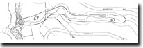
| Location: | 316722. Lower 400 m of the valley of Earimil Creek (formerly Dennant Creek). | 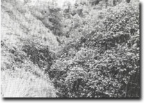 Site 67, Difficult geological conditions, Earimil Creek |
Access: | Wimborne Ave. | |
Ownership/Managing Authority: | Crown land, Shire of Mornington. | |
Site Description: | The creek floor crosses basalt, until about 400 m from the coast where the Balcombe Clay outcrops. The contact with the basalt is obscured but the structure is considered to be the Manyung Fault crossing the stream at approximately a right angle. | |
Significance: | Regional. The site is one of the few inland exposures of the Manyung Fault and provides an interesting geological interpretation exercise. | |
Management Considerations: | Class 2. Because of the dense vegetation growth in the valley, access to, and viewing of the outcrops is difficult. A cleared and maintained track along the valley between Wimborne Ave and the beach would greatly improve the amenity of the site. | |
References: | Gostin, V.A. (1966). Tertiary stratigraphy of the Mornington district, Victoria. I, 79, 459-512. | |

© State of Victoria (Agriculture Victoria) 1996 - .

This work, Victorian Resources Online, is licensed under a Creative Commons Attribution 4.0 licence. You are free to re-use the work under that licence, on the condition that you credit the State of Victoria (Agriculture Victoria) as author, indicate if changes were made and comply with the other licence terms.
The licence does not apply to ‘branding’ or some ‘images or photographs’ that may be owned by third parties. We ask you to seek prior approval to use images using the VRO feedback form. Access to higher quality images can also be provided on request.
This page was last updated on .