
206. Fairhaven - Dune Lake
|
This information has been developed from one or more of these publications:
|
| Location: | Barrallier - 501542. 4 km north of Tankerton. | 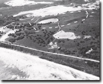 Dune lake at Fairhaven. Dotted line shows catchment, Site 206. |
Access: | By private vehicle track east of the Coast Road. | |
Ownership: | Private land. | |
Geology/Geomorphology: | This site represents a particularly well preserved dune lake. Inter-dune areas in the Aeolian sands of the north-west of French Island are typically swampy where drainage is impeded by topography or impervious horizons close to the surface. Bore records indicate that the aeolian sands were deposited over gently sloping fault apron sediments which are at shallow depths below inter-dune swales. This has resulted in the development of ‘perched’ lagoons or isolated areas of restricted drainage. A large number of shallower and larger inter-dune swales of this area of French Island have been drained and used as grazing land. | |
Significance: | Regional. The site represents a classic geomorphic feature which is not preserved on similar areas of Cranbourne Sand topography on the mainland. The site is the only inter-dune lagoon on French Island which is surrounded by well preserved dune ridges. | |
| Management: | Class 1. To preserve the morphology of the site it is essential that no artificial drainage of the lake be permitted. Extensive withdrawal of water should not be permitted, agricultural or other wastes should not be directed to the area and no more than minimal disturbance should be permitted in the catchment area. The depth of water retained in the lake at the end of a long dry period indicates that the lagoon is supplemented by ground waters or seepage from adjacent areas of impeded drainage. The area of liquid waste disposal prohibition should include the groundwater catchment as well as the topographic catchment of the lake. | |
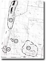 Sites 204 to 207, North of Tankerton |

© State of Victoria (Agriculture Victoria) 1996 - .

This work, Victorian Resources Online, is licensed under a Creative Commons Attribution 4.0 licence. You are free to re-use the work under that licence, on the condition that you credit the State of Victoria (Agriculture Victoria) as author, indicate if changes were made and comply with the other licence terms.
The licence does not apply to ‘branding’ or some ‘images or photographs’ that may be owned by third parties. We ask you to seek prior approval to use images using the VRO feedback form. Access to higher quality images can also be provided on request.
This page was last updated on .