
184. McHaffie Lagoon
|
This information has been developed from one or more of these publications:
|
| Location: | Somers – 393390. 1 km west of Black Hill. | 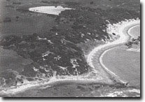 Cliff-top dunes (foreground) and McHaffie Lagoon, Site 184. |
| Access: | No public road access is available. The site may be reached by a coastal walk of 2 km from McHaffie Point. | |
| Ownership: | Part Crown land and part private land. | |
| Geomorphology: | This lagoon is the largest of a group of three dune blocked depressions on the Western Passage shoreline of Phillip Island, (the others are Flynn Lagoon and Green Lake). The lake floor is elevated several metres above sea level and lies on a coastal bench or terrace rather than occupying a valley. The catchment is therefore very small and the lake must be fed partly by springs. Its base probably lies on an impervious clay layer of weathered tuff or basalt, and ground water is fed from the enclosing dunes. The dunes are cliff-top dunes that rest on a low plateau surface and are relatively stable. | |
| Significance: | Regional. The lagoon is the least disturbed of the three referred to above. It illustrates an unusual process of coastal lake accumulation where most water is supplied by springs. | |
| Management: | Class 1. The lake and dune system are liable to be degraded by grazing pressure or defoliation of the enclosing dunes. It is recommended that stock be excluded from watering in the lagoon and alternative farm water supplies be arranged if required. | |
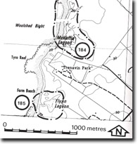 Sites 184 & 185, McHaffie Lagoon and Flynn Lagoon |

© State of Victoria (Agriculture Victoria) 1996 - .

This work, Victorian Resources Online, is licensed under a Creative Commons Attribution 4.0 licence. You are free to re-use the work under that licence, on the condition that you credit the State of Victoria (Agriculture Victoria) as author, indicate if changes were made and comply with the other licence terms.
The licence does not apply to ‘branding’ or some ‘images or photographs’ that may be owned by third parties. We ask you to seek prior approval to use images using the VRO feedback form. Access to higher quality images can also be provided on request.
This page was last updated on .