
50. Hastings - Ordovician and Silurian Outcrops
|
This information has been developed from one or more of these publications:
|
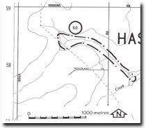
| Location: | Tyabb – 379583. Two kilometres west of Hastings. | |
| Access: | Coolart Road. | |
| Ownership: | Private land. | |
| Geology: | Weathered sediments outcrop in the base of the Warringine Creek on both sides of Coolart Road. Near the road crossing the sediments are predominantly mudstones and are Silurian, while 800 metres upstream they are sandstones of Upper Ordovician age. | |
| Significance: | Regional. While the exposures are poor, they represent one of the few areas where the transitional from Ordovician to Silurian sediments may be traced in the western side of the Westernport Bay. | |
| Management: | Class 2. Reclamation or construction works that would obscure the valley floor should not be permitted. | |

© State of Victoria (Agriculture Victoria) 1996 - .

This work, Victorian Resources Online, is licensed under a Creative Commons Attribution 4.0 licence. You are free to re-use the work under that licence, on the condition that you credit the State of Victoria (Agriculture Victoria) as author, indicate if changes were made and comply with the other licence terms.
The licence does not apply to ‘branding’ or some ‘images or photographs’ that may be owned by third parties. We ask you to seek prior approval to use images using the VRO feedback form. Access to higher quality images can also be provided on request.
This page was last updated on .