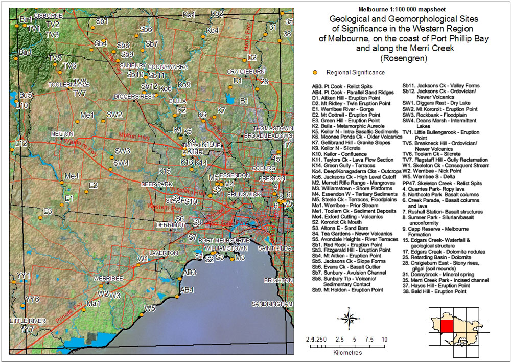
| Geological and Geomorphological Sites of Significance in the Western Region of Melbourne, on the coast of Port Phillip Bay and along the Merri Creek |
Regional Significance |  |
| AB3 - Pt Cook - Relict Spits | Sb6 - Evans Ck - Basalt Outlier |
| AB4 - Pt Cook - Parallel Sand Ridges | Sb7 - Sunbury - Avulsion Channel |
| D1 - Aitken Hill - Eruption Point | Sb8 - Sunbury Tip - Volcanic/Sedimentary Contact |
| D2 - Mt Ridley - Twin Eruption Point | Sb9 - Mt Holden - Eruption Point |
| E1 - Werribee River - Gorge | Sb11 - Jacksons Ck - Valley Forms |
| E2 - Mt Cottrell - Eruption Point | Sb12 - Jacksons Ck - Ordovician/Newer Volcanics |
| E3 - Green Hill - Eruption Point | SW1 - Diggers Rest - Dry Lake |
| K2 - Bulla - Metamorphic Aureole | SW2 - Mt Kororoit - Eruption Point |
| K5 - Keilor N - Intra-Basaltic Sediments | SW3 - Rockbank - Floodplain |
| K6 - Moonee Ponds Ck - Older Volcanics | SW4 - Deans Marsh - Intermittent Lakes |
| K7 - Gellibrand Hill - Granite Slopes | TV1 - Little Bullengarook - Eruption Point |
| K9 - Keilor N - Silcrete | TV5 - Breakneck Hill - Ordovician/Newer Volcanics |
| K10 - Keilor - Confluence | TV6 - Toolern Ck - Silcrete |
| K11 - Taylors Ck - Lava Flow Section | TV7 - Flagstaff Hill - Gully Reclamation |
| K14 - Green Gully - Terraces | W1 - Skeleton Ck - Consequent Stream |
| Ko4 - Deep/Konagaderra Cks - Outcrops | W2 - Werribee - Nick Point |
| Ko6 - Jacksons Ck - High Level Cutoff | W5 - Werribee S - Delta |
| M2 - Merrett Rifle Range - Mangroves | PP47 - Skeleton Creek - Relict Spits |
| M3 - Williamstown - Shore Platforms | 4 - Quarries Park - Ropy Lava |
| M4 - Essendon W - Tertiary Sediments | 5 - Northcote Park - Basalt Columns |
| M5 - Steele Ck - Sediment Deposits | 6 - Creek Parade - Basalt Columns and Lava |
| Ma1 - Werribee - Prior Stream | 7 - Rushall Station - Basalt Structures |
| Me1 - Toolern Ck - Sediment Deposits | 8 - Summer Park - Silurian/Basalt Conformity |
| Mo4 - Exford Cutting - Volcanics | 9 Capp Reserve - Melbourne Formation |
| S2 - Kororoit Ck Mouth | 15 - Edgars Creek - Waterfall and Geological Structure |
| S3 - Altona E - Sand Bars | 17 - Edgars Creek - Dolomite Nodules |
| S4 - Tea Gardens - Newer Volcanics | 25 - Retarding Basin - Dolomite |
| S5 - Avondale Heights - River Terraces | 28 - Craigieburn East - Stony Rises, Gilgai (soil mounds) |
| Sb1 - Red Rock - Eruption Point | 31 - Donnybrook - Mineral Spring |
| Sb3 - Fitzgerald Hill - Eruption Point | 35 - Merri Creek Park - Incised Channel |
| Sb4 - Mt Aitken - Eruption Point | 38 - Hayes Hill - Eruption Point |
| Sb5 - Jacksons Ck - Slope Forms | 39 - Bald Hill - Eruption Point |