
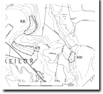
K9 Keilor North - Silcrete
|
This information has been developed from the publications:
|
| Location Access Ownership | Keilor - -73250. Former City of Keilor. Southern side of Maribyrnong River 2.5 km northwest of Keilor. Calder Freeway Private land | 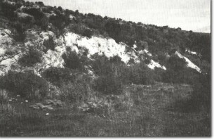 K9 - Silcrete and Newer Volcanics, Jacksons Creek. |
Site Description | On the southern valley slopes of the Maribyrnong River, a small disused quarry exposes a section of Silurian sediments underlying Older Volcanics basalt. Above the Older Volcanics are sandy sediments, indurated to silcrete, and overlying these are flows of Newer Volcanics basalt. | |
Significance | Regional The site is an example of a geological contact and a substantial outcrop of sub-basaltic silcrete. It is an uncommon example of both Older and Newer Volcanics exposed in the one section. | |
Management | The slope should be left in existing condition to allow display of the geological features described. | |

© State of Victoria (Agriculture Victoria) 1996 - 2025.

This work, Victorian Resources Online, is licensed under a Creative Commons Attribution 4.0 licence. You are free to re-use the work under that licence, on the condition that you credit the State of Victoria (Agriculture Victoria) as author, indicate if changes were made and comply with the other licence terms.
The licence does not apply to ‘branding’ or some ‘images or photographs’ that may be owned by third parties. We ask you to seek prior approval to use images using the VRO feedback form. Access to higher quality images can also be provided on request.
This page was last updated on 23/11/2018.