
D1 Aitken Hill (Mount Yuroke) - Eruption Point
|
This information has been developed from the publications:
|
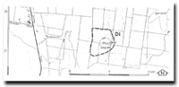
| Location | Donnybrook - 150353. Shire of Bulla. One kilometre north of Greenvale Reservoir. | 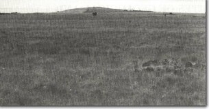 D1 - The low basalt dome of Aitken Hill and the adjacent lava plain, Craigieburn. |
Access | Patullos Lane. | |
Ownership | Private property. | |
Site Description | The site is an eruption point in the Newer Volcanics with a summit elevation of 265 metres. It is a composite volcanic cone built of scoria and lava flows with scoria predominant on the eastern side. At the summit is a V-shaped wall of basalt three metres high and two metres wide which remnant of a lava plug. Several lava flows issued from this plug including blocky and ropy lava and scoria. | |
Significance | Regional. The eruption point is one of the closest to the metropolitan area and is readily distinguishable as a volcanic feature. It is an example of the major geological process that has shaped the terrain to the north of Melbourne. | |
Management | Class 2: To maintain the distinctive form of the volcano and to preserve the summit plug and erupted rocks, it would be necessary to limit building on the hill to below the 230 metre contour. Quarrying of the summit area should not be permitted. Structures that project to or above the summit would also detract from the significance of the feature. | |
Reference | Hanks, W. (1955). Newer Volcanic Vents and Lava Fields between Wallan and Yuroke, Victoria. Proc. R. Soc. Vict. 67:1-15. | |

© State of Victoria (Agriculture Victoria) 1996 - 2025.

This work, Victorian Resources Online, is licensed under a Creative Commons Attribution 4.0 licence. You are free to re-use the work under that licence, on the condition that you credit the State of Victoria (Agriculture Victoria) as author, indicate if changes were made and comply with the other licence terms.
The licence does not apply to ‘branding’ or some ‘images or photographs’ that may be owned by third parties. We ask you to seek prior approval to use images using the VRO feedback form. Access to higher quality images can also be provided on request.
This page was last updated on 23/11/2018.