
M5 Steele Creek - Terraces, Floodplain
|
This information has been developed from the publications:
|
| Location Access Ownership | Maribyrnong - 128190. Former City of Keilor. Valley of Steele Creek between Buckley Street and the Maribyrnong River. Buckley Street, Brees Road Crown land | 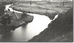 Terrace (arrow) and delta at mouth of Steele Creek, Essendon West. |
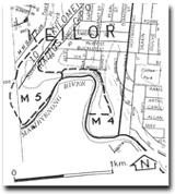
Site Description | The site includes two terrace levels west of Steele Creek. The higher terrace level represents the valley of the creek when it entered the Maribyrnong 500 m west of the present junction. Incision of the higher terrace by Steele Creek diverted the stream to its present position as the valley was deepened below the level of the old outlet. A narrow deltaic deposit has been built at the present stream junction. The lower terrace is the modern floodplain and includes abandoned meanders on adjacent low terraces. | |
Significance | Regional. The site illustrates aspects of the geomorphological history of the Maribyrnong valley and its tributaries and includes fluvial deposits from several stages of valley development. It is a very clear example of two stage terrace development and is one of the few relatively unmodified alluvial floodplain reaches of the Maribyrnong River tributaries in the metropolitan area. | 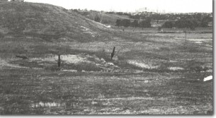 M5 - Cutoff meander (arrows) on floodplain of Steele Creek, Essendon West. |
Management | Class 1. Drainage diversion or artificial straightening of Steele Creek would degrade the facilities of interest. The floodplain should not be reclaimed or filled and a maximum amount of unmodified open space should be retained in the stream valley. |

© State of Victoria (Agriculture Victoria) 1996 - 2025.

This work, Victorian Resources Online, is licensed under a Creative Commons Attribution 4.0 licence. You are free to re-use the work under that licence, on the condition that you credit the State of Victoria (Agriculture Victoria) as author, indicate if changes were made and comply with the other licence terms.
The licence does not apply to ‘branding’ or some ‘images or photographs’ that may be owned by third parties. We ask you to seek prior approval to use images using the VRO feedback form. Access to higher quality images can also be provided on request.
This page was last updated on 23/11/2018.