
Ko4 Deep Creek and Konagaderra Creek - Outcrops
|
This information has been developed from the publications:
|
| Location | Konagaderra - 104438. Shire of Bulla. Valley of Deep Creek at junction of Konagaderra Creek 2.5 km west of Donnybrook Road. | 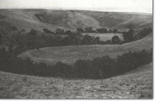 Ko4 - Incised meanders of Deep Creek, Mickleham. |
Access | Kinnear Road of Mickleham Road | |
Ownership | Private land | |
Site Description | Erosion by Deep Creek has stripped off the cover of the Newer Volcanics basalt to expose Ordovician and Silurian sediments. The zone of stripping is widest on the west of the creek and here only small outliers of weathered volcanics remain close to the creek as hill cappings. | |
The Silurian sediments strike north-south and at this site the strike of the sediments determines the orientation of spurs and short reaches of stream channel. The processes of valley widening involving slumping, mass movement and retreat of the basalt edge are well displayed on the western valley slopes of Deep Creek. | ||
Significance | Regional. Dissection of basalt surfaces by Deep Creek and its tributaries, and the development of landforms determined by structures of the underlying Palaeozoic sediments is well displayed at this site. These features are typical of the geology and landforms of the area between the Hume Highway and the Calder Highway in the study area. | |
Management | Further building construction, quarrying or soil extraction, apart from that necessary to service the existing properties, should not be permitted on this site. | |

© State of Victoria (Agriculture Victoria) 1996 - 2025.

This work, Victorian Resources Online, is licensed under a Creative Commons Attribution 4.0 licence. You are free to re-use the work under that licence, on the condition that you credit the State of Victoria (Agriculture Victoria) as author, indicate if changes were made and comply with the other licence terms.
The licence does not apply to ‘branding’ or some ‘images or photographs’ that may be owned by third parties. We ask you to seek prior approval to use images using the VRO feedback form. Access to higher quality images can also be provided on request.
This page was last updated on 23/11/2018.