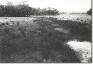
Ma1 Werribee - Prior Stream of Werribee Delta
|
This information has been developed from the publications:
|
| Location | Manor - 903978. Former Shire of Werribee. Section of channel of Lollypop creek, south of the Princes Highway one kilometre west of the Maltby By-Pass Road. |  Ma1 - Shallow channel of Lollypop Creek, a distributary stream of the Werribee delta. |
| Access | Old Boundary Road. | |
| Ownership | Crown land (MMBW Farm). | |
Site Description | The site is a shallow meandering section of the channel of Lollypop Creek. This stream is an abandoned distributary channel or prior stream of the system that fed from the Werribee River to deposit the sediments of the Werribee River Delta. These channels were active during a higher sea level episode in the Pleistocene. Lollypop Creek no longer links with the Werribee River as the main channel of the river is now incised deeply into the delta sediments and the creek has been abandoned as an ephemeral channel. | |
Significance | Regional. Lollypop Creek is one of the last unmodified examples of the formerly extensive distributary channel system of the Werribee River. Most other channel systems lie within the pond system of the MMBW farm, or are on private land and have been considerably modified by agricultural activities. The channel is an example of the processes that produced the extensive sedimentary body of the Werribee River Delta. It is evidence that the delta was built as a subaerial feature by terrestrial streams and is not a true subaqueous delta. | |
Management | Class 1. The channel system should be retained in its present form and not be filled, drained or submerged. Changes in land use should be planned to maintain this form. | |


