
Me1 Toolern Creek, Melton - Sediment Deposits
|
This information has been developed from the publications:
|
| Location | Melton - 892295. Shire of Melton. Valley of Toolern Creek at ‘Ridham Park’ 4 km northeast of Melton. | 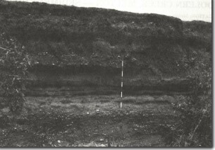 Me1 - Bedded sands and gravels of the Toolern Creek north of Melton. |
Access | Ryans Road or Gisborne to Melton Road. | |
Ownership | Crown land and private land. | |
Site Description | The creek channel exposes a 6 m section of alluvial deposits. The deposits included well-rounded and bedded gravels with clast 4 to 6 cm long, cross-bedded sands, and silty horizons. The sediment is of mixed origin and includes basalt pebbles from the Newer Volcanics as well as sandstones and quartzites from the Palaeozoic rocks. Concentrations of charcoal occur in some horizons and there is at least one palaeosol (buried soil) 1 m below the top of the section. | |
Significance | Regional. The site is an excellent example of rapidly deposited valley fill that has subsequently been dissected. It is a very useful teaching site to illustrate the stages of the sedimentary history of a tributary of the Werribee River system, and to demonstrate the substantial amount of material that has been eroded from the Gisborne highlands. | |
Management | Class 1. The section should not be reclaimed, quarried or stabilized. Roadworks or bridge replacement should be designed to retain an off-road parking area and retain the steep and clean section at the site. | |
References | Condon, M.A. (1951). The Geology of the Lower Werribee River, Victoria. Proc. R. Soc. Vict. 63:1-24. | |

© State of Victoria (Agriculture Victoria) 1996 - 2025.

This work, Victorian Resources Online, is licensed under a Creative Commons Attribution 4.0 licence. You are free to re-use the work under that licence, on the condition that you credit the State of Victoria (Agriculture Victoria) as author, indicate if changes were made and comply with the other licence terms.
The licence does not apply to ‘branding’ or some ‘images or photographs’ that may be owned by third parties. We ask you to seek prior approval to use images using the VRO feedback form. Access to higher quality images can also be provided on request.
This page was last updated on 23/11/2018.