K7 Gellibrand Hill - Granite Slopes
|
This information has been developed from the publications:
|
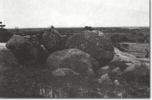
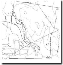
| Location | Keilor - 123303. Shire of Bulla. Northeastern section of Gellibrand Park. |  K7 - Granite boulders Gellibrand Hill. |
| Access | Swain Street of Mickleham Road. | |
| Ownership | Crown land. | |
Site Description | The site is the summit and southern slopes of Gellibrand Hill where there are outcrops and small tors of Bulla Granodiorite. Granite was quarried from this site last century and used in construction of the Melbourne Town Hall and Old Princes Bridge. Evidence of the quarrying can still be seen on some boulders. | |
The outcrop is part of the large circular stock that outcrops intermittently from Greenvale to Bulla, the lower lying sectors being buried beneath flows of Newer Basalt. The granite has intruded Silurian sediments and although these do not outcrop in the Park, pebbles of shales and hornfels found in the shallow valley of the creek near the southeastern edge of the Park indicate the proximity of the contact zone. On the lower hillslopes are accumulations of coarse granitic colluvium. | ||
Significance | Regional. The site is the closest example of granitic terrain to the metropolitan region. It is one of the few sites where locally obtained stone, other than basalt, was used in building construction in Melbourne. It is a clear example of minor landforms typical of granitic terrain. | |
Management | Class 3. The site should be maintained as public open space (Gellibrand Park). Building construction on the areas should not be permitted. Stream and slope processes should be left in existing condition. | |
References | Stillwell, F,L. (1911). Notes on the Geology of Broadmeadows. Proc. R. Soc. Vict. 24:156-178. | |


