
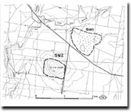
SW1 Diggers Rest - Dry Lake
|
This information has been developed from the publications:
|
| Location Access Ownership | Sydenahm West - 945305. Shire of Melton. North of Holden Road and east of Kororoit Creek, 4 km southwest of Diggers Rest. Holden Road. Private land | 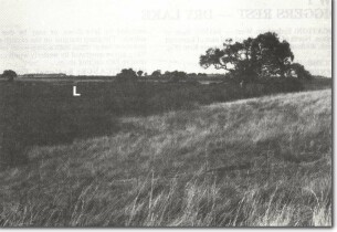 SW1 - Dry lake on lava plain near Mount Kororoit. |
Site Description | The site is a circular enclosed depression, 600 m in diameter, in the surface of the basalt plain, the margins marked by a well-defined bluff 6 to 8 m high. A small valley enters the depression in the northeast and there is natural drainage to Kororoit Creek to the west. The site has been artificially drained and the alluvial floor is now cultivated. The origin of the depression is uncertain. It may be an eruption point (a small explosion crater or maar), a depression enclosed by lava flows, or may be due to subsidence. The steep margins on the eastern side suggest there has been at times a deep water body, with wave action generated by westerly winds cutting an erosive face on this shore. | |
Significance | Regional. Few other depressions on the Werribee Plains are bounded by such well-defined scarps. It is therefore a distinctive feature in the present study area. There has been no detailed study of the origins of the depression. | |
Management | Class 2. Continuation in agricultural land use is appropriate to maintaining the significance of the site. No buildings should be permitted on the escarpment slopes and the site should not be crossed by roadways. In the long term, restoration of the area to a wetland would be appropriate. | |

© State of Victoria (Agriculture Victoria) 1996 - 2025.

This work, Victorian Resources Online, is licensed under a Creative Commons Attribution 4.0 licence. You are free to re-use the work under that licence, on the condition that you credit the State of Victoria (Agriculture Victoria) as author, indicate if changes were made and comply with the other licence terms.
The licence does not apply to ‘branding’ or some ‘images or photographs’ that may be owned by third parties. We ask you to seek prior approval to use images using the VRO feedback form. Access to higher quality images can also be provided on request.
This page was last updated on 23/11/2018.