
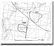
SW2 Mount Kororoit - Eruption Point
|
This information has been developed from the publications:
|
| Location | Sydenham West - 936298. Shire of Melton. Conical hill 8 m north of Melton and west of Leakes Road. | |
Access | Leakes Road. | |
Ownership | Private land | |
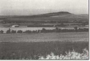
Site Description | Mount Kororoit is a small conical hill about 1500 m around the base and rising 100 m above the surrounding terrain. The hill is predominantly a scoria mound with the summit capped by a rocky outcrop of lava agglomerate. | |
Several narrow parallel and arcuate ridges of vesicular basalt lava are prominent on the slopes immediately below the summit. Similar ridges and lava capping are seen on many of the eruption points on the Werribee Plains and the Gisborne district, and several explanations have been offered for their origin. | ||
Significance | Regional. Mount Kororoit is a fine example of the eroded volcanoes of the Gisborne - Melton district. It has been the subject of a recent detailed geophysical study that has produced a different hypothesis for the origin of the radial and parallel ridges. | |
Management | Class 2. Continuation of agricultural land use at the present intensity is consistent with maintaining the significance of the site. Residential development should not be permitted on the area of the site. | |
References | Edwards, A.B. and Crawford, W. (1940). The Cainozoic Volcanic Rocks of the Gisborne District, Victoria. Proc. R. Soc. Vict. 52:281-311. Singleton, O.P. (1973). Geology of the Bacchus Marsh District, In, McAndrew J. and Marsden, M.A.H., Regional Guide to Victorian Geology. School of Geol., Univ. Melb. 59-64. VandenBerg, A.H.M. (1973). Geology of the Melbourne District. In, McAndrew, J. and Marsdens, M.A.H. Regional Guide to Victorian Geology. School of Geol., Univ. Melb. 14-30. Fischer, W.S. and Thomas, L. (19821). A study of Mt Kororoit, Victoria: A Small Volcanic Vent. Proc. R. Soc. Vict 93:99-103. | |
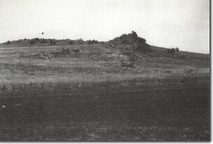
SW2 - Radial squeeze-up ridges, Mount Kororoit.
Related sites on VRO
- Eruption points of the Newer Volcanics - Mount Kororoit

© State of Victoria (Agriculture Victoria) 1996 - 2025.

This work, Victorian Resources Online, is licensed under a Creative Commons Attribution 4.0 licence. You are free to re-use the work under that licence, on the condition that you credit the State of Victoria (Agriculture Victoria) as author, indicate if changes were made and comply with the other licence terms.
The licence does not apply to ‘branding’ or some ‘images or photographs’ that may be owned by third parties. We ask you to seek prior approval to use images using the VRO feedback form. Access to higher quality images can also be provided on request.
This page was last updated on 23/11/2018.