
K11 Taylors Creek - Lava Flow Section
|
This information has been developed from the publications:
|
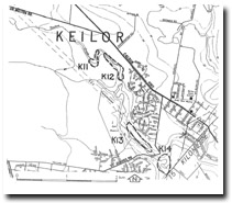
| Location | Keilor - 072239. Former City of Keilor. Valley of Taylors Creek immediately upstream of Hakea Road Bridge. |  K11 - Jointed lava flows, Taylors Creek, Taylors Lakes. Note building rubble in foreground. |
Access | Hakea Road. | |
Ownership | Crown land | |
Site Description | A 7 m high cliff, formed by the incision of Taylors Creek into the basalt of the Keilor Plains, exposes two lava flows of the Newer Volcanics. The lower flow has well developed columnar jointing while the upper flow has closely spaced horizontal fractures. The flow boundary, 1.5 m above creek level, is clearly marked by a red, ropey lava surface on the lower flow. | |
Significance | Regional. The site is a very clear and safely accessible natural section of a lava sequence occurring on public land. Although thee are extensive lava surfaces in the study region, there are relatively few public accessible examples of flow boundaries. This site is possibly the best example observed that meets the above criteria. | |
Management | Class 2. The site is robust but environmental quality of the locality is being rapidly degraded by proximity to housing development and deterioration of watery quality in the pool at the cliff base. Building and domestic refuse has been recently dumped over the cliff edge partly obscuring the outcrops. A maintained public reserve is required at the site to ensure the maintenance of site quality. The cliff should be retained in its natural state. |

© State of Victoria (Agriculture Victoria) 1996 - .

This work, Victorian Resources Online, is licensed under a Creative Commons Attribution 4.0 licence. You are free to re-use the work under that licence, on the condition that you credit the State of Victoria (Agriculture Victoria) as author, indicate if changes were made and comply with the other licence terms.
The licence does not apply to ‘branding’ or some ‘images or photographs’ that may be owned by third parties. We ask you to seek prior approval to use images using the VRO feedback form. Access to higher quality images can also be provided on request.
This page was last updated on .