
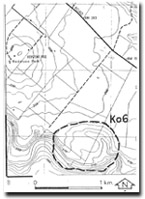
Ko6 Jacksons Creek - High Level Cutoff
|
This information has been developed from the publications:
|
| Location | Konagaderra - 025340. Shire of Bulla. Northern side of Jacksons Creek 4 km northwest of Bulla. | |
| Access | Private road from Bulla - Sunbury Road. | |
| Ownership | Private land. | |
| Site Description | A bowl shaped depression 30 m above channel level on the northern side of Jacksons Creek, is an abandoned meander of the river formed at an earlier stage in the incision of the valley. The bluffs that flank the depression are abandoned river cliffs, while the slightly raised area in the middle is the remains of the meander spur that was breached during the development of the cutoff. | |
| Significance | Regional. The site is one of the best example of a high level cutoff along Jacksons Creek. | |
Management | Class 2. Retention of the site under rural land use is an appropriate way to maintain the significance of the feature. | |

© State of Victoria (Agriculture Victoria) 1996 - 2025.

This work, Victorian Resources Online, is licensed under a Creative Commons Attribution 4.0 licence. You are free to re-use the work under that licence, on the condition that you credit the State of Victoria (Agriculture Victoria) as author, indicate if changes were made and comply with the other licence terms.
The licence does not apply to ‘branding’ or some ‘images or photographs’ that may be owned by third parties. We ask you to seek prior approval to use images using the VRO feedback form. Access to higher quality images can also be provided on request.
This page was last updated on 23/11/2018.