
Sb9 Mount Holden - Eruption Point
|
This information has been developed from the publications:
|
| Location | Sunbury - 964400. Shire of Bulla. North of Calder Highway 2 km west of Sunbury. | 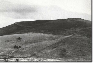 Sb9 - Lava ridges, Mt Holden. |
Access | Reservoir Road | |
Ownership | Private land | |
Site Description | Mount Holden (412 m) is one of the most prominent of the eroded volcanic hills between Sunbury and Gisborne. It has a complex summit with rocky cliffs and ridges facing east and a gentler western slope with fewer outcrops. The outcrops are the last of the lava flows from the summit area of the volcano, the vent becoming infilled with this solidified lava and surrounded by a rim of scoria. Erosion has since removed the scoria, leaving the rims of lava around the summit which obscure the vent of the volcano. | |
The eruption occurred in an area of hilly terrain developed on Ordovician sediments. These sediments have been exposed by Blink Creek which has stripped off the thin cover of lava so the volcanic material are now outliers almost surrounded by the older rocks. | ||
Significance | Regional. The mountain has a more complex summit than the other volcanic hills in the district. The site shows the contrasting slopes produced by volcanic activity with the adjacent terrain developed on Ordovician sediments. | |
Management | Class 2. The site should be kept in rural land use or reserved for use as a public open space system. Buildings should not be permitted above the 330 m contour as this would detract from the significant form of the volcano. | |

© State of Victoria (Agriculture Victoria) 1996 - 2025.

This work, Victorian Resources Online, is licensed under a Creative Commons Attribution 4.0 licence. You are free to re-use the work under that licence, on the condition that you credit the State of Victoria (Agriculture Victoria) as author, indicate if changes were made and comply with the other licence terms.
The licence does not apply to ‘branding’ or some ‘images or photographs’ that may be owned by third parties. We ask you to seek prior approval to use images using the VRO feedback form. Access to higher quality images can also be provided on request.
This page was last updated on 23/11/2018.