
M2 - Merrett Rifle Range - Mangroves, Salt Marsh, Shore Platform
|
This information has been developed from the publications:
|
| Location | Maribyrnong - 144067. Former City of Williamstown. Coastline at southern end of Merrett Rifle Range, Williamstown. | 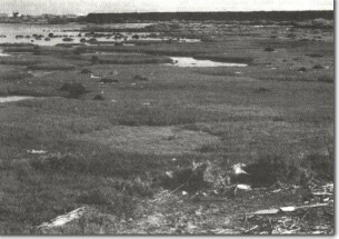 M2 - Sarcocornia hummocks, Merrett Rifle Range. |
| Access | Kororoit Creek Road. (The area is closed to the public and entry can only be obtained by obtaining advanced written permission from the Defence Department). | |
| Ownership | Crown land (Defence Department). | |
| Site Description | Four features of significance occur at the southern end of the Rifle Range (Nos 1 to 4). | |
| No 1 is an intertidal area with hummocks of Sarcocornia quinqueflora acting as a vegetative agent in coastal accretion. The Sarcocornia is growing in roughly circular mounds which are in various stage of development and are enclosing formerly open intertidal area. New Sarcocornia growth then extends into the sheltered and shallowing pools gradually reducing the area of open intertidal water. The site therefore presents a mosaic of different aged stands of Sarcocornia and appears to be gradually causing minor progradation of the coast. | ||
| No. 2 is a shore platform of Newer Volcanics Basalt. The basalt is massively jointed and breaks the platform into a series of 4 to 6 sided blocks, the joints having been enlarged by weathering and wave action. The largest blocks are over 2 m in diameter. The highest surface of the platform is approximately 1m above high water mark and the surface slopes landward to be buried by deposits of sand, silt and shells. | 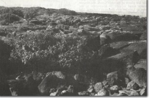 M2 - Avicennia marina (White Mangrove) and basalt shore platform, Merrett Rifle Range. | |
| No. 3 is the occurrence of Avicennia marina (White Mangrove) growing on the rocky platform and in a muddy intertidal lagoon behind the platform. At this point, a breach in the platform has been widened by wave action and a small circular lagoon has been eroded in the sediments that lie over the basalt. The mangroves occur along a 200 m sector of the coast and include numerous seedlings and juveniles as well as mature plants. Some plants survive in exposed position with their roots established in small pockets of sediment lodged in the fractured basalt. | ||
| No. 4 is a 1.5 m high break of slope eroded into the shell deposits 100 m inland and roughly parallel to the coast. The feature may be a former shoreline. | ||
| Significance | Regional. The site has high regional significance due to the several different features that occur in a small area. The mangroves are the largest surviving stand in the northern sector of Port Phillip Bay and one of only three remnant mangrove communities known in the Bay. Apart from the few plants at Kororoit Creek, the nearest comparable stand is over 50 km to the southwest of Limeburners Bay near Geelong. |  M2 - Mangroves (arrowed) and blocky shore platform, Merrett Rifle Range. |
| The site demonstrates the capacity of mangroves to grown on rocky substrates in exposed conditions as well on sheltered lagoonal shores. This occurrence on a rocky substrate is uncommon the Victorian coast. The basalt platform is of unusual form and along with the low cliff and shell deposits inland, could be taken to be evidence for a slightly higher sea level. The role of Sarcocornia in promoting accretion in the manner described above is also unusual. | ||
| Management | Class 1. The area has enjoyed protection by the closure of the coast for defence purposes. The activities of the rifle range have only had a slight impact on the character of the site, being confined to some minor quarrying and filling that has had little impact on the mangroves. | |
| From a scientific viewpoint, it is preferable that the site be retained at its present level of usage. If the site is to be retained by the Defence Department, no further reclamation or construction work should be permitted that would alter the significant features described. If the rifle range is transferred to another authority for alternative uses, the significant features should be reserved from any physical alteration. No reclamation, construction, drainage or coastal installations should be permitted and road or property drainage should not be transmitted through the mangrove area. The area could be incorporated into a coastal walking system but intensive 'off-track' use would lead to a deterioration of the marsh system. Vehicular traffic, in particular motor bikes, should be prohibited and this prohibition would need to be rigidly enforced. | ||
| References | Jutson, J.T. (1931). Erosion and Sedimentation in Port Phillip Bay, Victoria. Proc. R. Soc. Vict. 43:323-349. McDougall, K.D. 1986). Significance |

© State of Victoria (Agriculture Victoria) 1996 - 2025.

This work, Victorian Resources Online, is licensed under a Creative Commons Attribution 4.0 licence. You are free to re-use the work under that licence, on the condition that you credit the State of Victoria (Agriculture Victoria) as author, indicate if changes were made and comply with the other licence terms.
The licence does not apply to ‘branding’ or some ‘images or photographs’ that may be owned by third parties. We ask you to seek prior approval to use images using the VRO feedback form. Access to higher quality images can also be provided on request.
This page was last updated on 23/11/2018.