
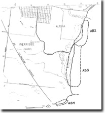
AB3 Point Cook - Relict Spits
|
This information has been developed from the publications:
|
| Location Access Ownership | Altona Bay - 065030 south to 062007. Former Shire of Werribee. Coastal area between Skeleton Creek and Point Cook. Point Cook Homestead Road. Crown land | |
Site Description | To the south of Skeleton Creek is an area of lagoons and low sand and shell ridges seaward of the old Cheetham Salt works. The floor of the lagoons is basalt buried by silty sand and mud and the ridges are remnants of spits formed in a marine embayment now sealed by the growth of an outer sand ridge system. | |
The form of the sand ridges is similar to the active spit systems north of Skeleton Creek, although some of the lobate forms that extend landward from the main ridge may have been built by storm washover before the growth of the present outer ridge system. This wetland complex occupies a depression in the basalt surface that was breached and flooded by the rising Holocene seas 6,000 to 8,000 years ago. It has been modified since then by the growth of the sandy spits, by washover and by accumulation of lagoonal muds. The site includes the near shore sand bar system. | ||
Significance | Regional. The site is an example of several relict coastal landforms and forms an interesting comparison with the active coastal features to the north of Skeleton Creek. | |
Management | Class 2. The area has limited recreational potential but comprises an important wetland habitat. Any dredging, drainage or reclamation work that may take place to enhance this potential should be designed to avoid modifying the sand ridge systems and offshore bars of the site. | |
References | Jutson, J.T. (1931). Erosion and Sedimentation in Port Phillip Bay, Victoria. Proc. R. Soc. Vict. 43:164-174. | |

© State of Victoria (Agriculture Victoria) 1996 - 2025.

This work, Victorian Resources Online, is licensed under a Creative Commons Attribution 4.0 licence. You are free to re-use the work under that licence, on the condition that you credit the State of Victoria (Agriculture Victoria) as author, indicate if changes were made and comply with the other licence terms.
The licence does not apply to ‘branding’ or some ‘images or photographs’ that may be owned by third parties. We ask you to seek prior approval to use images using the VRO feedback form. Access to higher quality images can also be provided on request.
This page was last updated on 23/11/2018.