
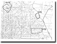
TV1 Little Bullengarook (Fairies Hill) - Eruption Point
|
This information has been developed from the publications:
|
| Location | Toolern Vale - 803457. Former Shire of Gisborne. East of Little Bullengarook 7 km southwest of Gisborne. |
Access | White Road off Gisborne - Bacchus Marsh Road. |
Ownership | Private land and some Crown land. |
Site Description | The eruption of Little Bullengarook buried gravels and sands developed in stream valleys and on valley side slopes. Subsequent dissection of the lava flows has revealed the base of the lava and the underlying gravels, many of which have been hardened by cementation by silica precipitated from groundwaters. Along the eastern sides of Little Bullengarook and at the head of Dunns Gully to the south, the contact between the lava flows and the silicified gravels is exposed. |
Significance | Regional. The site display lithology and geological contacts important in determining the chronology of the lava flows and the nature of the pre-basaltic terrain. |
Management | Class 3. Continuation of land use in agriculture, forestry or catchment protection will maintain the significance of the site. |
References | Crawford, W. (1939). The Physiography of the Gisborne Highlands. Proc. R. Soc. Vict. 52:262-279. |

© State of Victoria (Agriculture Victoria) 1996 - 2025.

This work, Victorian Resources Online, is licensed under a Creative Commons Attribution 4.0 licence. You are free to re-use the work under that licence, on the condition that you credit the State of Victoria (Agriculture Victoria) as author, indicate if changes were made and comply with the other licence terms.
The licence does not apply to ‘branding’ or some ‘images or photographs’ that may be owned by third parties. We ask you to seek prior approval to use images using the VRO feedback form. Access to higher quality images can also be provided on request.
This page was last updated on 23/11/2018.