
Sb1 Red Rock - Eruption Point
|
This information has been developed from the publications:
|
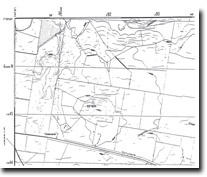
| Location | Sunbury - 917453. Shire of Bulla. Northern side of Western Highway 7 km east of Gisborne. | 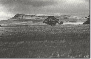 Sb1 - Red Rock, a lava capped eruption point with scoria. |
Access | Dalrymple Road | |
| Ownership | Private land | |
Site Description | Red Rock is a prominent eruption point similar in form to Mt Holden and Mt Aitken, with a more or less flat top surrounded by rock cliffs except, for the eastern side where there is a long gentle slope descending to the surrounding lava plain. There is a scoria rim which has been partly quarries and exposes a section of the red scoria from which the mount derives its name. | |
Significance | Regional. Red Rock is a significant landscape feature of the plains to the east of Gisborne. The hill contains a higher percentage of scoria than normally occurs in the volcanoes of the Gisborne district. | |
| Management | Class 2. The hill should not be subject to residential subdivision above the 450 m contour. |

© State of Victoria (Agriculture Victoria) 1996 - 2025.

This work, Victorian Resources Online, is licensed under a Creative Commons Attribution 4.0 licence. You are free to re-use the work under that licence, on the condition that you credit the State of Victoria (Agriculture Victoria) as author, indicate if changes were made and comply with the other licence terms.
The licence does not apply to ‘branding’ or some ‘images or photographs’ that may be owned by third parties. We ask you to seek prior approval to use images using the VRO feedback form. Access to higher quality images can also be provided on request.
This page was last updated on 23/11/2018.