Your gateway to a wide range of natural resources information and associated maps

Victorian Resources Online

Sites of Geological and Geomorphological Significance - Warragul - Regional and Local

Back to: Port Phillip & Westernport - Sites of Geological and Geomorphological Significance

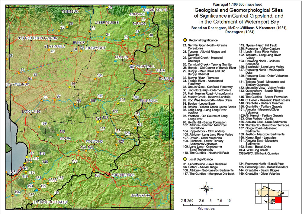
This is a clickable map. Click on Site in Legend for more information.

Sites of Geological and Geomorphological Significance - Warragul - Regional, Local

Sites of Geological and Geomorphological Significance - Warragul - Regional and Local
Regional Significance
21 Nar Nar Goon North - Granite corestones121 Loch - Bass River valley
23 Tynong - Allufical ridges and swamps122 Topiram - Lang Lang River valley
25 Cannibal Creek - Impeded drainage123 Poowerong North - Childers formation
26 Cannibal Creek - Tynong granite126 Strzelecki - Lang Lang valley
28 Bunyip - Old course of Bunyip River127 Poowong North - McDougalls Dyke
29 Bunyip - Main drain and old Bunyip channel129 Poowong East - Older volcanics residual
32 Bunyip River - Terraces131 Teloora Road - Mesozoic and Tertiary outcrops
34 Tarago River - Abandoned floodway132 Mountain View - Valley profile
35 Drouin West - Confined floodway143 Queensferry - Beach Ridges and Swamp
36 Jindivik quarry - Older volcanics145 The Gurdies - Baxter formation
37 Main Neerim Road - Unconformity146 St Heller - Mesozoic plant fossils
38 Muddy Creek - Inactive landslip148 Grantville - Barkers quarries
92 Koo Wee Rup North - Main drain150 Grantville - Tertiary gravels
93 Bayles - Levee bank151 Almurta - Mesozoic/Older volcanics
94 Bayles - Yallock creek levee banks152a/b Kernot - Tertiary gravels
95 Lang Lang - Old course of Lang Lang River153 Glen Forbes - Lignite
98 Heath Hill - Baxter formation155 Almurta east - Lake sediments
102 Athlone - Lang Lang River valley156 'Burnbank' - Bass River terraces
104 Ripplebrook - Old landslip157 Gorge Road - Masozoic sediments
105 Athlone - Silicified mesozoic sandstone159 Jeetho - Mesozoic sediments
107 Drouin - Older volcanics160 Kernot East - Landslips
108 Ellinbank - Lower tertiary sediments/volcanics161 Almurta East - Mesozoic sediments
109 Lang Lang - Cranbourne sand topography163 Bena - Basalt Dyke
118 The Gurdies - Heath Hill faultCG4 Wild Dog Creek
119 Nyora - Heath Hill faultCG5 a/b/c Ellinbank quarries
120 Poowong - Valley capture
Local Significance
31 Labertouche - Lava residual124 Poowong North - Basalt pipe
96 Catani - Alluvial ridge125 Poowong East - Basalt boulders
106 Athlone - Sub-basaltic sediments144 Grantville - Beach ridges
117 The Gurdies - Mangrove die-back149 Grantville - Older volcanics
Page top