
21. Nar Nar Goon North - Granite Corestones
|
This information has been developed from one or more of these publications:
|
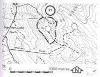
| Location: | Nar Nar Goon - 741912. One kilometre east of Nar Nar Goon North. | 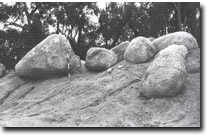 Excavated granite corestones, Nar Nar Goon North. |
Access: | Warren Road off Nar Nar Goon Road. | |
Ownership: | Private land. | |
Geology/Geomorphology: | The crest of a small hill has been quarried for granitic sands, the depth of the cut averaging two metres. The quarry has exposed a number of well-rounded granite corestones up to 2.5 metres diameter and these remain at the site. The exhumed corestones illustrate one stage in the process of boulder or tor development in these rocks. | |
Significance: | Regional. The site allows assessment to be made of the depth at which corestones form and clearly shows the process of sub-surface weathering and rounding of boulders re exposure at the surface. | |
Management: | Class 2. Extensive reclamation of abandoned quarry areas would conceal the significant features at the site. There is minimal erosion risk at the site and as reclamation is not desirable or necessary it should not be permitted. | |

© State of Victoria (Agriculture Victoria) 1996 - .

This work, Victorian Resources Online, is licensed under a Creative Commons Attribution 4.0 licence. You are free to re-use the work under that licence, on the condition that you credit the State of Victoria (Agriculture Victoria) as author, indicate if changes were made and comply with the other licence terms.
The licence does not apply to ‘branding’ or some ‘images or photographs’ that may be owned by third parties. We ask you to seek prior approval to use images using the VRO feedback form. Access to higher quality images can also be provided on request.
This page was last updated on .