
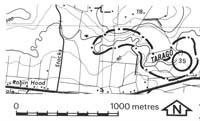
35. Drouin West - Tarago River Confined Flood Plain
|
This information has been developed from one or more of these publications:
|
Location: | Labertouche - 996838. Tarago river 1.5 kilometres east of Drouin West. | |
Access: | Old Sale Road and Stocks Road. | |
Ownership: | Crown Land (Public Land Water Frontage Reserve) and Private Land. | |
Geomorphology: | The flood plain of the Tarago River is here confined in a valley cut in sedimentary beds of the Walhalla Group. The flood plain is 400 metres wide and the Tarago has incised a channel to a depth averaging 5 metres, thus creating a bordering terrace. On this terrace are depressions marking former higher level channels of the river. On the northern valley slope are old landslips. | |
Significance: | Regional. The site is an example of a confined flood plain and is of interest as a monitoring site to assess recent changes in channel morphology and the impact of these changes on the adjacent valley slopes. | |
Management: | Class 2. Subdivision should not be permitted on the area of the site and straightening or realignment of the river channel should not be permitted. | |

© State of Victoria (Agriculture Victoria) 1996 - .

This work, Victorian Resources Online, is licensed under a Creative Commons Attribution 4.0 licence. You are free to re-use the work under that licence, on the condition that you credit the State of Victoria (Agriculture Victoria) as author, indicate if changes were made and comply with the other licence terms.
The licence does not apply to ‘branding’ or some ‘images or photographs’ that may be owned by third parties. We ask you to seek prior approval to use images using the VRO feedback form. Access to higher quality images can also be provided on request.
This page was last updated on .