
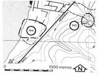
144. Grantville - Beach Ridges
|
This information has been developed from one or more of these publications:
|
Location: | Grantville - 726500. Two kilometres north of Grantville. | |
Access: | Bass Highway. | |
Ownership: | Private land and some Crown Land. | |
Geomorphology: | Several small sand ridges converge towards the south at the base of the Heath Hill Fault scarp. The landward edge of the ridges is marked by a low bluff which is a former marine cliff cut into slope foot colluvium. | |
Significance: | Local. The site is one of the few areas of coastal sand ridge accumulation on the eastern side of Westernport Bay. | |
Management: | Class 2. Extensive levelling of the terrain should not be permitted as this would obscure the pattern of sand ridges and the low bluff. | |

© State of Victoria (Agriculture Victoria) 1996 - .

This work, Victorian Resources Online, is licensed under a Creative Commons Attribution 4.0 licence. You are free to re-use the work under that licence, on the condition that you credit the State of Victoria (Agriculture Victoria) as author, indicate if changes were made and comply with the other licence terms.
The licence does not apply to ‘branding’ or some ‘images or photographs’ that may be owned by third parties. We ask you to seek prior approval to use images using the VRO feedback form. Access to higher quality images can also be provided on request.
This page was last updated on .