
23. Tynong - Alluvial Ridges and Swamp Deposits
|
This information has been developed from one or more of these publications:
|
| Location: | Nar Nar Goon - 772823 to Tonimbuk - 813802. Four kilometres south of Tynong. | 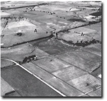 Low granite ridges (A) and abandoned channels and levees of the Bunyip River. |
Access: | Lone Pine Road, Tynong Catani Road, Daly Road, McGraws Road. | |
Ownership: | Private Land. | |
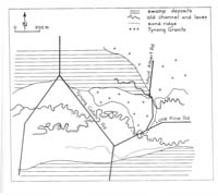
Geomorphology: | The site includes three groups of landforms. West of Lone Pine Road a low hill is and inlier of Tynong Granite surrounded by alluvium and swamp deposits. The trace of a former stream course is apparent where it crosses Lone Pine Road and the Tynong to Cantani road. The channel is flanked by sandy levee banks, and originated as a distributary on the Bunyip River alluvial fan. The very level terrain between Ararat Creek and the Tynong to Bayles road, is a tongue of drained swampland that represents the northernmost limits of the peaty deposits of the Koo-Wee-Rup Swamp. | |
Significance: | Regional. The site encloses the typical terrain types of the northern Koo-Wee-Rup Plain. | |
Management: | Class 2. Subdivision or extensive construction works and excavation should not be permitted on the area of the site. | |

© State of Victoria (Agriculture Victoria) 1996 - .

This work, Victorian Resources Online, is licensed under a Creative Commons Attribution 4.0 licence. You are free to re-use the work under that licence, on the condition that you credit the State of Victoria (Agriculture Victoria) as author, indicate if changes were made and comply with the other licence terms.
The licence does not apply to ‘branding’ or some ‘images or photographs’ that may be owned by third parties. We ask you to seek prior approval to use images using the VRO feedback form. Access to higher quality images can also be provided on request.
This page was last updated on .