
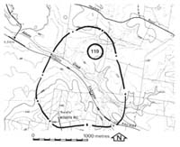
119. Nyora - Heath Hill Fault
|
This information has been developed from one or more of these publications:
|
Location: | Nyora - 810590 to 825567. Four kilometres north-west of Nyora. | |
Access: | McDonalds Track, Heylens Road. | |
Ownership: | Crown Land and some private land | |
Geology: | The site includes the trace of the Heath Hill Fault. Baxter Formation sediments are exposed on the downthrown (western) and upthrown (eastern) blocks including one outlier in the railway cutting 1.5 kilometres west of Nyora. In the valley of a small creek south of the railway lines, Mesozoic sediments are seen to underlie the Baxter Formation sediments. West of the fault scarp, the Baxter Formation is largely buried by Cranbourne Sand and outcrops are confined to inliers at the ridge crests. | |
Significance: | Regional. The site displays the physiographic expression of the Heath Hill Fault and allows assessment to be made of the displacement by comparing the elevations of the Baxter Formation. | |
Management: | Class 3. The significance of features of interest at the site will be unlikely to be reduced by changes in land use. | |

© State of Victoria (Agriculture Victoria) 1996 - .

This work, Victorian Resources Online, is licensed under a Creative Commons Attribution 4.0 licence. You are free to re-use the work under that licence, on the condition that you credit the State of Victoria (Agriculture Victoria) as author, indicate if changes were made and comply with the other licence terms.
The licence does not apply to ‘branding’ or some ‘images or photographs’ that may be owned by third parties. We ask you to seek prior approval to use images using the VRO feedback form. Access to higher quality images can also be provided on request.
This page was last updated on .