
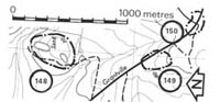
148. Grantville - Barkers Quarried (Baxter Formation)
|
This information has been developed from one or more of these publications:
|
Location: | Grantville - 729475. One kilometre east of Grantville. | |
Access: | Grantville Road. | |
Ownership: | Private land. | |
Geology: | This large quarry provides extensive exposure of a range of lithologies of the Baxter Formation. The sediments are commonly cross-bedded coarse sands and gravels with clay clasts and fine sand beds. Clear examples of the steep dips imparted by the Heath Hill Fault are evident and there are other minor faults. | |
Significance: | Regional. This is an important exposure of Baxter Formation affected by Heath Hill Fault. | |
Management: | Class 2. Quarry management guidelines should be applied here. | |

© State of Victoria (Agriculture Victoria) 1996 - .

This work, Victorian Resources Online, is licensed under a Creative Commons Attribution 4.0 licence. You are free to re-use the work under that licence, on the condition that you credit the State of Victoria (Agriculture Victoria) as author, indicate if changes were made and comply with the other licence terms.
The licence does not apply to ‘branding’ or some ‘images or photographs’ that may be owned by third parties. We ask you to seek prior approval to use images using the VRO feedback form. Access to higher quality images can also be provided on request.
This page was last updated on .