
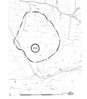
109. Lang Lang - Cranbourne Sand Topography
|
This information has been developed from one or more of these publications:
|
Location: | Lang Lang - 766600. Four kilometres south-east of Lang Lang. | |
Access: | Lang Lang to Nyora road or walk along the South Eastern Railway. | |
Ownership: | Crown Land and private land. | |
Geology/Geomorphology: | The site encloses an area of characteristic topography of Cranbourne Sand, with short curving ridge crests and internal drainage depressions. These depressions typically contained small lakes, but natural swamp encroachment and artificial drainage have eliminated most areas of open water. The north-western margin of the site is marked by a gently curving long ridge which lies adjacent to a flat area that is a drained lake basin. The ridge marks the shoreline of the now dry lake and was shaped by wave action rather than wind deposition. | |
Significance: | Regional. The site has been selected to illustrate the nature of Cranbourne Sand topography on the eastern side of Westernport Bay. The distribution of this formation is limited here to the area south-east of Lang Lang. | |
Management: | Class 2. Extensive clearing and draining of the wetlands in the site should not be permitted. Some sand quarrying could be permitted as this provides sections into the Cranbourne sand. Roadworks should be planned to avoid disturbing the swampy depressions. | |

© State of Victoria (Agriculture Victoria) 1996 - .

This work, Victorian Resources Online, is licensed under a Creative Commons Attribution 4.0 licence. You are free to re-use the work under that licence, on the condition that you credit the State of Victoria (Agriculture Victoria) as author, indicate if changes were made and comply with the other licence terms.
The licence does not apply to ‘branding’ or some ‘images or photographs’ that may be owned by third parties. We ask you to seek prior approval to use images using the VRO feedback form. Access to higher quality images can also be provided on request.
This page was last updated on .