
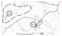
105. Athlone - Lang Lang River Valley
|
This information has been developed from one or more of these publications:
|
Location: | Ripplebrook - 920676. Seven kilometres east of Heath Hill. | 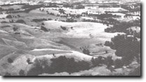 River-cut bluff on northern side of Lang Lang River valley, Athlone. |
Access: | Cliftons Road. | |
Ownership: | Private land and Crown Land (Public Land Water Frontage Reserve). | |
Geology/Geomorphology: | The Lang Lang River is incised into the uplifted fault block west of the Heath Hill scarp. The valley profile is markedly asymmetrical with a steep and in places undercut erosion bluff on the northern side, but the southern valley slope lacks a distinct river-cut bluff. The valley is alluviated with a flood plain 500 to 700 metres wide, the river channel occupying the northern side of the flood plain. The depth of stream channel incision increases towards the west as the knickpoint referred to in Site 100 is approached. This knickpoint will continue to extend upstream resulting in a deepening and widening of the river channel. The broad valley and degree of alluviation of the Pheasant Creek is suggestive of back tilting of the fault block east of the Heath Hill Fault (Jenkin, pers.comm.). | |
Significance: | Regional. The site encloses terrain that is of major importance in elucidating the tectonic and erosional history of the western margin of the South Gippsland Highlands. | |
Management: | Class 3. Changes in land use will not affect the significant features of the site. The progress upstream of the knickpoint will pose a hazard to the stability of the flood plain banks (Bird 1981) and should be carefully monitored. | |
References: | Bird, J. F. , 1981. Geomorphological implication of flood control measures, Lang Lang River, Victoria. Aust. Geog. Stud. 169-183. | |

© State of Victoria (Agriculture Victoria) 1996 - .

This work, Victorian Resources Online, is licensed under a Creative Commons Attribution 4.0 licence. You are free to re-use the work under that licence, on the condition that you credit the State of Victoria (Agriculture Victoria) as author, indicate if changes were made and comply with the other licence terms.
The licence does not apply to ‘branding’ or some ‘images or photographs’ that may be owned by third parties. We ask you to seek prior approval to use images using the VRO feedback form. Access to higher quality images can also be provided on request.
This page was last updated on .