
38. Muddy Creek - Inactive Landslip
|
This information has been developed from one or more of these publications:
|
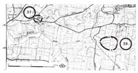
Location: | Tarago - 064843. Two kilometres north of Buln Buln. | |
Access: | Brandy Creek Road. | |
Ownership: | Private land. | |
Geology/Geomorphology: | A bowl-shaped rotational landslip with a distinct headwall scarp and hummocky terrain below occurs on the northern valley slope of Muddy Creek. The slip is inactive but probably post-dates European settlement of the area. It occurs on a hillslope at the weathered contact between Older Volcanics basalt and the underlying Devonian sedimentary rocks. | |
Significance: | Regional. Landslips of this dimension are not common on the lithology in the study area. | |
Management: | Class 3. Any change in land use would not reduce the significance of the site. | |

© State of Victoria (Agriculture Victoria) 1996 - .

This work, Victorian Resources Online, is licensed under a Creative Commons Attribution 4.0 licence. You are free to re-use the work under that licence, on the condition that you credit the State of Victoria (Agriculture Victoria) as author, indicate if changes were made and comply with the other licence terms.
The licence does not apply to ‘branding’ or some ‘images or photographs’ that may be owned by third parties. We ask you to seek prior approval to use images using the VRO feedback form. Access to higher quality images can also be provided on request.
This page was last updated on .