
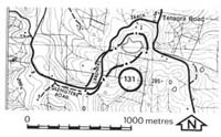
131. Tetoora Road - Mesozoic and Tertiary Outcrops
|
This information has been developed from one or more of these publications:
|
Location: | Mount Worth - 024627. Fifteen kilometres south of Warragul. | |
Access: | Lardners Track. | |
Ownership: | Crown Land and private land. | |
Geology: | Grey mudstone taken from roadside cuttings of Lardners Tract have yielded plant impressions of the Zone 'C', Gingkoites australis zone (Douglas, 1969). The hillcrest to the south-west of the Lardners Track junction with the Warragul-Korumburra road is capped with Childers Formation sediments which are exposed in a small quarry. | |
Significance: | Regional. The site is one of few documented Mesozoic fossil localities in the Westernport region. | |
Management: | Class 2. Changes in land use will not alter the significant features at the site. | |

© State of Victoria (Agriculture Victoria) 1996 - .

This work, Victorian Resources Online, is licensed under a Creative Commons Attribution 4.0 licence. You are free to re-use the work under that licence, on the condition that you credit the State of Victoria (Agriculture Victoria) as author, indicate if changes were made and comply with the other licence terms.
The licence does not apply to ‘branding’ or some ‘images or photographs’ that may be owned by third parties. We ask you to seek prior approval to use images using the VRO feedback form. Access to higher quality images can also be provided on request.
This page was last updated on .