
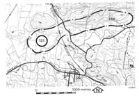
121. Loch - Bass River Valley
|
This information has been developed from one or more of these publications:
|
Location: | Nyora - 865534 to 885535. The site extends along the Bass River valley from west of Loch towards Poowong. | 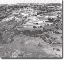 Asymmetrical valley of the Bass River between Loch and Poowong. |
Access: | Ferriers Road. | |
Ownership: | Crown Land (Public Land Water Frontage Reserve) and private land. | |
Geomorphology: | The Bass River is notable for the extensive development of two sets of river terraces that extends for almost 40 kilometres along the valley. They are well displayed between Bass and Poowong and have been studied in some detail by Brennan (1972). Upstream from the Ferriers Road bridge, several small rapids occur where the Bass River is incised through the alluvial fill and exposes the Mesozoic sedimentary rock. Tickell (1971) mapped three terrace levels in the valley here but Brennan (1972) showed that the lowest level comprised slumped material and was not due to alluvial terracing. The Bass valley narrows north of Loch as the influence of the alignment imparted by the Almurta Fault disappears. The northern valley slope upstream from the Ferriers Road bridge has a number of old landslip scars. The valley is markedly asymmetrical with a steep northern valley side slope contrasting with the gentle slopes of the southern side. | |
Significance: | Regional. The site represents one of the major river terraces sequences in Victoria and illustrates the control exercised by faulting on the alignment of the Bass River valley. | |
Management: | Class 2. Quarrying of the terrace material in the area of the site could be permitted on a limited scale. Re-grading and re-alignment of the river channel and intensive subdivision of the terrace areas should not be permitted. | |
References: | Brennan, I.D., 1972. Quaternary studies of two Western Port environments. B.Sc (Hons) thesis (unpub.) Dept. of Geology Univ. of Melb. Tickell, S.J., 1971. The geology of the Bass River Area. B.Sc. Hons thesis (unpub.) Dept. of Geol. Univ. of Melb. | |

© State of Victoria (Agriculture Victoria) 1996 - .

This work, Victorian Resources Online, is licensed under a Creative Commons Attribution 4.0 licence. You are free to re-use the work under that licence, on the condition that you credit the State of Victoria (Agriculture Victoria) as author, indicate if changes were made and comply with the other licence terms.
The licence does not apply to ‘branding’ or some ‘images or photographs’ that may be owned by third parties. We ask you to seek prior approval to use images using the VRO feedback form. Access to higher quality images can also be provided on request.
This page was last updated on .