
143. Queensferry - Beach Ridges and Swamp
|
This information has been developed from one or more of these publications:
|
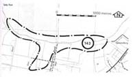
Location: | Grantville - 7004673. Two kilometres south-west of Grantville. | |
Access: | Old Queensferry Road. | |
Ownership: | Crown Land and private land. | |
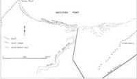
Geomorphology: | The coast west of Queensferry is a drained lowland that is probably a former deltaic and flood plain area of the Bass River. Sandy ridges that cross the lowland are remnants of former spits and beach ridges, these being most distinct in the eastern part of the site. Sand ridges and spits are extending behind the mangrove fringe from the east and west. Stages in the growth of these ridges may be observed in the spit that is developing in the mangrove fringe west of Old Queensferry Road. | |
Significance: | Regional. The site illustrates the extensive nature of sand movement in the Quensferry area and the role of easterly drift in developing the coarse landforms here. | |
Management: | Class 2. Small scale quarrying of the inland sand ridges could be permitted and access roads or tracks across the area would not affect the nature of the features of significance. Structures that would divert or intercept the eastward drift of sand should not be permitted as this may lead to erosion of beaches at Queensferry and Grantville. | |

© State of Victoria (Agriculture Victoria) 1996 - .

This work, Victorian Resources Online, is licensed under a Creative Commons Attribution 4.0 licence. You are free to re-use the work under that licence, on the condition that you credit the State of Victoria (Agriculture Victoria) as author, indicate if changes were made and comply with the other licence terms.
The licence does not apply to ‘branding’ or some ‘images or photographs’ that may be owned by third parties. We ask you to seek prior approval to use images using the VRO feedback form. Access to higher quality images can also be provided on request.
This page was last updated on .