
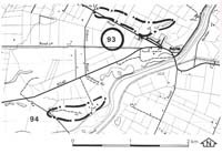
93. Bayles - Levee Bank
|
This information has been developed from one or more of these publications:
|
Location: | Bayles - 745735. Opposite the Bayles Primary School. | 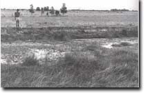 Sandy levee and former channel of Yallock Creek at Bayles. |
Access: | Phillips Road. | |
Ownership: | Private land. | |
Geomorphology: | A former course of the Yallock Creek is marked by a swampy depression flanked by sandy levee banks. The Bayles area is distinctive in the Koo-Wee-Rup Swamp because of the number of raised sandy levee banks left by former high energy streams which drained across this area prior to the development of the main swamps. | |
Significance: | Regional. The site is a clear example of the sandy levees which are characteristic of the former stream courses in the Bayles area. | |
Management: | Class 2. Quarrying or levelling and construction works on the levee banks and drainage and filling of the depression would destroy the properties of the site. These activities should be prohibited in order to maintain the site. | |
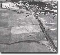 Traces of levee banks (arrowed) marking former courses of Yallock Creek, Bayles. |

© State of Victoria (Agriculture Victoria) 1996 - .

This work, Victorian Resources Online, is licensed under a Creative Commons Attribution 4.0 licence. You are free to re-use the work under that licence, on the condition that you credit the State of Victoria (Agriculture Victoria) as author, indicate if changes were made and comply with the other licence terms.
The licence does not apply to ‘branding’ or some ‘images or photographs’ that may be owned by third parties. We ask you to seek prior approval to use images using the VRO feedback form. Access to higher quality images can also be provided on request.
This page was last updated on .