
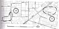
29. Bunyip - Main Drain and Old Bunyip Channel
|
This information has been developed from one or more of these publications:
|
| Location: | Tonimbuk - 882810. One kilometre south of Bunyip. | 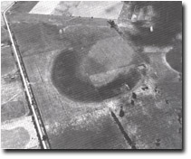 Abandoned large amplitide manner of Bunyip prior stream. |
Access: | Main Drain Road South Side. | |
Ownership: | Private land. | |
Geomorphology: | The main drain here intersects a channel of the old course of the Bunyip River. although overgrown, the walls of the drain provide a section of flood plain sediments and these may be compared with the sediments that fill the old river channel. An abandoned meander of the river has a much greater amplitude than most other meanders of the same stream and may represent a prior or very early channel pattern of the Bunyip River. | |
Significance: | Regional. The site allows for an examination of the stratigraphy of the flood plain and channel sediments of the Bunyip River. | |
Management: | Class 2. Artificial lining of the channel wall should not be permitted here, as this would obscure the significant geological section. Filling or reclamation of the large abandoned meander should not be permitted. | |

© State of Victoria (Agriculture Victoria) 1996 - .

This work, Victorian Resources Online, is licensed under a Creative Commons Attribution 4.0 licence. You are free to re-use the work under that licence, on the condition that you credit the State of Victoria (Agriculture Victoria) as author, indicate if changes were made and comply with the other licence terms.
The licence does not apply to ‘branding’ or some ‘images or photographs’ that may be owned by third parties. We ask you to seek prior approval to use images using the VRO feedback form. Access to higher quality images can also be provided on request.
This page was last updated on .