
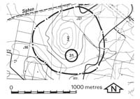
31. Labertouche - Lava Residual
|
This information has been developed from one or more of these publications:
|
Location: | Labertouche - 953905. Two kilometres north of Labertouche. | |
Access: | Forest Road. | |
Ownership: | Private land. | |
Geology: | A distinctive conical hill isolated by a meander of Two Mile Creek is a capping of Older Volcanics basalt resting in the eroded surface of the Tynong Granite. | |
Significance: | Local. The site is an example of the topographic expression of the basalt residuals. | |
Management: | Class 3. Any change in land use will not alter the significance of the site. | |

© State of Victoria (Agriculture Victoria) 1996 - .

This work, Victorian Resources Online, is licensed under a Creative Commons Attribution 4.0 licence. You are free to re-use the work under that licence, on the condition that you credit the State of Victoria (Agriculture Victoria) as author, indicate if changes were made and comply with the other licence terms.
The licence does not apply to ‘branding’ or some ‘images or photographs’ that may be owned by third parties. We ask you to seek prior approval to use images using the VRO feedback form. Access to higher quality images can also be provided on request.
This page was last updated on .