
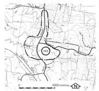
122. Topram - Lang Lang River Valley
|
This information has been developed from one or more of these publications:
|
Location: | Poowong - 963634. Twelve kilometres south of Drouin South. | 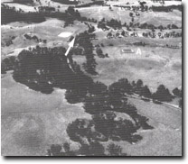 Beheaded valley (arrow), structural or erosion bench (A), Lang Lang River floodplain. |
Access: | Main South Road. | |
Ownership: | Private land. | |
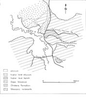
Geology/Geomorphology: | The Lang Lang River occupies a confined flood plain bounded by well defined valley side bluffs. These are cut in Mesozoic sediments which outcrop in the cuttings of the Main South Road to the east of the river. On the northern valley slope is a slumped area which is an outcrop of Childers Formation overlain by weathered tuffs and basalts of the Older Volcanics. The northern valley slope of the tributary that lies south of the Torwood - Topiram road has a broad bench or terrace 10 to 150 metres above the level of the flood plain. This may be a structural terrace, or it may be an abandoned or captured higher level valley floor remnant of a former northward draining stream now beheaded by the Lang Lang River. | |
Significance: | Regional. The site is of interest for the outcrop of Tertiary rocks and the unusual nature of the valley slope bench. | |
Management: | Class 3. changes in land use will nor reduce the nature of the significant features at the site. | |

© State of Victoria (Agriculture Victoria) 1996 - .

This work, Victorian Resources Online, is licensed under a Creative Commons Attribution 4.0 licence. You are free to re-use the work under that licence, on the condition that you credit the State of Victoria (Agriculture Victoria) as author, indicate if changes were made and comply with the other licence terms.
The licence does not apply to ‘branding’ or some ‘images or photographs’ that may be owned by third parties. We ask you to seek prior approval to use images using the VRO feedback form. Access to higher quality images can also be provided on request.
This page was last updated on .