
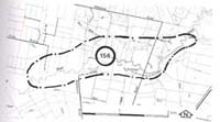
156. Burnbank - Bass River Terraces
|
This information has been developed from one or more of these publications:
|
Location: | Grantville - 700413 to Corinella - 685410. Bass River valley four kilometres north-east of Bass. | |
Access: | Mapleson Road. | |
Ownership: | Crown Land (Public Land Water Frontage Reserve) and private land. | |
Geomorphology: | The site includes two terraces of the Bass River. It is also the site where a major avulsion of the channel has taken place giving rise to the present course of the Bass River. Traces of the former channel that extended to the north and entered Westernport Bay near Corinella are discernible on the northern side of the floodplain. | |
Significance: | Regional. The terrace sequence of the Bass River is clearly displayed at this site. The avulsion channel is an example of a major change in the drainage direction of the Bass River. | |
Management: | Class 2. Continuation of the present rural land use is consistent with maintaining the significant features of the site. Extensive excavation of the material of the lower terrace should not be permitted. Extensive construction work and residential subdivision should not be permitted on the area of the site as this would obliterate the traces of the old channels. | |

© State of Victoria (Agriculture Victoria) 1996 - .

This work, Victorian Resources Online, is licensed under a Creative Commons Attribution 4.0 licence. You are free to re-use the work under that licence, on the condition that you credit the State of Victoria (Agriculture Victoria) as author, indicate if changes were made and comply with the other licence terms.
The licence does not apply to ‘branding’ or some ‘images or photographs’ that may be owned by third parties. We ask you to seek prior approval to use images using the VRO feedback form. Access to higher quality images can also be provided on request.
This page was last updated on .